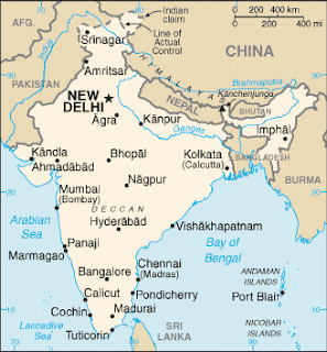
Geography And Maps Of India:
The Indus
Valley civilization, one of the world's oldest, flourished during the
3rd and 2nd centuries BCE and extended into northwestern India. Aryan
tribes from the northwest infiltrated onto the Indian subcontinent about
1500 BCE; their merger with the earlier Dravidian inhabitants created
the classical Indian culture. The Maurya Empire of the 4th and 3rd
centuries BCE - which reached its zenith under Ashoka - united much of
South Asia. The Golden Age ushered in by the Gupta dynasty (4th to 6th
centuries CE) saw a flowering of Indian science, art, and culture. Arab
incursions starting in the 8th century and Turkic in the 12th were
followed by those of European traders, beginning in the late 15th
century. By the 19th century, Britain had assumed political control of
virtually all Indian lands. Indian armed forces in the British army
played a vital role in both World Wars. Nonviolent resistance to British
colonialism led by Mohandas Gandhi and Jawaharlal Nehru brought
independence in 1947. The subcontinent was divided into the secular
state of India and the smaller Muslim state of Pakistan. A third war
between the two countries in 1971 resulted in East Pakistan becoming the
separate nation of Bangladesh. India's nuclear weapons testing in 1998
caused Pakistan to conduct its own tests that same year. Despite
pressing problems such as significant overpopulation, environmental
degradation, extensive poverty, and widespread corruption, rapid
economic development is fueling the country's rise on the world stage.
Facts:
Capital: New Delhi
Major Cities: Mumbai, Kolkata, Bangalore and Chennai
Area: 1,269,219 square miles (3,287,263 sq km)
Bordering Countries: Bangladesh, Bhutan, Burma, China, Nepal and Pakistan
Facts:
Updated February 06, 2011
Population: 1,173,108,018 (July 2010 estimate)Capital: New Delhi
Major Cities: Mumbai, Kolkata, Bangalore and Chennai
Area: 1,269,219 square miles (3,287,263 sq km)
Bordering Countries: Bangladesh, Bhutan, Burma, China, Nepal and Pakistan
Coastline: 4,350 miles (7,000 km)
Highest Point: Kanchenjunga at 28,208 feet (8,598 m)
India, formally called the Republic of India, is the country that occupies most of the Indian subcontinent in southern Asia. In terms of its population, India is one of the most populous nations in the world and falls slightly behind China. India has a long history and is considered the world's largest democracy and one of the most successful in Asia. It is a developing nation and has only recently opened its economy to outside trade and influences. As such, its economy is currently growing and when combined with its population growth, India is one of the world's most significant countries.

No comments:
Post a Comment